Storm Christoph set to bring heavy rain and disruption to Harrogate district this week
and live on Freeview channel 276
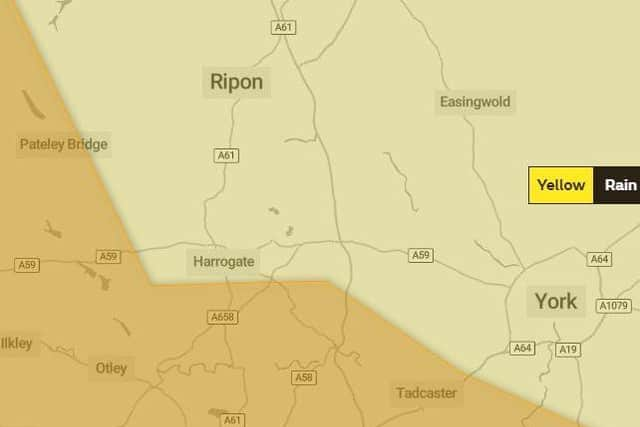
A 'Yellow' weather warning for rain is in place for the majority of the Harrogate district across Tuesday, Wednesday and Thursday, with other parts of Yorkshire being issued with a more severe 'Amber' warning, which highlights a 'danger to life'.
This has been issued for the North Leeds, Wetherby and Tadcaster area, as well as parts of Nidderdale, which could affect the district bringing in the worst of the conditions.
Advertisement
Hide AdAdvertisement
Hide AdThe Met Office says persistent heavy rain will lead to significant accumulations of rain which could lead to flooding in some areas.

Heavy rain is expected to start at 6am on Tuesday and continue on and off right through to midday on Thursday, with the more serious conditions expected between Tuesday morning and Wednesday night.
Chief Meteorologist Dan Suri, said “Following a cold spell where the main hazard was snow, our focus now turns to notably heavy rain moving across the UK this week. Some locations could see over 100mm of rain falling through the course just a couple of days with up to 200mm possible over higher ground. These amounts of rainfall along with snow melt present a real threat of flooding and people should keep a close eye on flood warnings from the Environment Agency and Natural Resources Wales.
“As the system moves away into the North Sea Wednesday night and Thursday morning there will be strong winds along the east coast for a time. Meanwhile, colder air coming southwards into the weather system brings the risk of further snow on the back edge of this system. Temperatures will gradually fall across the UK through the end of the week and into the weekend bringing a return to widespread overnight frosts.”
What does a Yellow weather warning mean?
Advertisement
Hide AdAdvertisement
Hide AdSpells of prolonged and heavy rain may lead to flooding and disruption to travel in places.
Homes and businesses could be flooded, causing damage to some buildings
Fast flowing or deep floodwater is possible, causing a danger to life
Delays or cancellations to train and bus services are possible
Advertisement
Hide AdAdvertisement
Hide AdSpray and flooding could lead to difficult driving conditions and some road closures
Some communities may be cut off by flooded roads
Possible power cuts and loss of other services to some homes and businesses.
What is the forecast for Harrogate?
Tuesday, January 19:
6am: RAIN
7am: HEAVY RAIN
8am: HEAVY RAIN
9am: HEAVY RAIN
10am: HEAVY RAIN
11am: HEAVY RAIN
12pm: HEAVY RAIN
1pm: HEAVY RAIN
2pm: HEAVY RAIN
3pm: HEAVY RAIN
4pm: HEAVY RAIN
5pm: HEAVY RAIN
6pm: HEAVY RAIN
7pm: HEAVY RAIN
8pm: RAIN
9pm: RAIN
10pm: HEAVY RAIN
11pm: HEAVY RAIN
Wednesday, January 20:
12am: HEAVY RAIN
3am: RAIN
6am: RAIN
9am: HEAVY RAIN
MIDDAY: HEAVY RAIN
3pm: HEAVY RAIN
6pm: HEAVY RAIN
9pm: HEAVY RAIN
Thursday, January 21:
12am: RAIN
3am: RAIN
6am: RAIN
9am: CLOUDY
12pm: SUNNY SPELLS