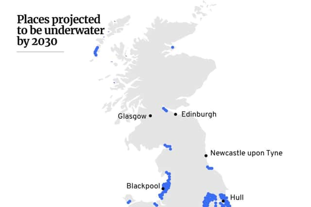
This map by climate scientists shows which parts of the UK could be underwater in the next decade


Large swathes of the UK will be underwater by 2030 as a result of climate change if more isn’t done to combat it, according to a projection by a climate research organisation.
Many coastal areas will be impacted by rising sea levels and parts of Britain’s coastline will move significantly inland, with the east of England particularly affected.
Advertisement
Hide AdAdvertisement
Hide AdRising sea levels will affect people in all regions of the UK within the next decade, according to the map.
Which areas will be affected?
London, Cardiff, Edinburgh and Belfast will all be significantly impacted by rising sea levels, as well as many smaller towns and cities in coastal areas.
The projected map has been put together by Climate Central, a research organisation which aims to show the real impacts of climate change.
Based on scientific evidence on various climate change measures, including carbon emissions, Climate Central’s tool shows how rising sea levels could impact the whole world over the next 90 years.
Advertisement
Hide AdAdvertisement
Hide AdUsing the tool, you can look at projected impacts after different periods of time, and based on different criteria. The primary map shows a mid-range scenario, based on an assumption that there will be moderate cuts to emissions.
It is also based on a mid-level projection of sea level rises, although there is an option to show what the impact would be in a more pessimistic potential scenario.


You can look in more depth at the map here, to see the potential impact of climate change on the UK and the rest of the world, between now and 2100.
Here are some of the towns and cities which are set to be left fully or partially underwater by 2030 according to the map:
- Aberystwyth
- Barrow-in-Furness
- Belfast
- Beverley
- Blackpool
- Boston
- Cardiff
- Chichester
- Doncaster
- Edinburgh
- Falkirk
- Glasgow
- Gloucester
- Hartlepool
- Hull
- King’s Lynn
- Leith
- Llanelli
- London
- Middlesbrough
- Morecambe
- Newcastle upon Tyne
- Portsmouth
- Scunthorpe
- Southend
- Stirling
- Warrington