Thunderstorms in Yorkshire: Yellow weather warning issued across Yorkshire - here is when thunderstorms will hit Leeds, York, Sheffield, Halifax, Bradford, Doncaster, Huddersfield, Wakefield and Harrogate

and live on Freeview channel 276
The Met Office predicts a more unsettled weekend of weather ahead for some areas; whilst temperatures will remain above average for this time of year, a low-pressure system in the Atlantic is bringing in more rain into the forecast, with possibility of this falling as thundery downpours for some.
On Friday, June 16, a large majority of the UK experienced high temperatures and clear, sunny skies. However, the risk of more showers and thunder is expected to increase in these areas into Saturday, June 17. There is a trend to more showers and thunderstorms through the weekend, resulting in a yellow thunderstorm warning being issued for a large part of England and Wales on Sunday, June 18.
Advertisement
Hide AdAdvertisement
Hide AdMet Office deputy chief meteorologist, Chris Almond, said: “Over the weekend we’ll be transitioning to a more unsettled regime for the UK, though temperatures will remain high and it’ll feel very humid for many.
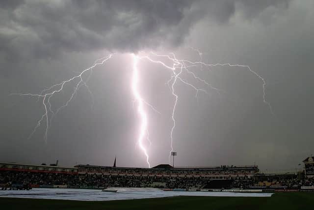

“Heavy showers and thunderstorms are likely to become more frequent and impactful through the weekend, with the potential for associated hail, lightning and some gusty winds. The risk of thundery downpours initially starts in the far west on Friday afternoon, but spreads more widely through the weekend, resulting in the warning the Met Office has issued.
“There’s an ongoing likelihood of further warnings being issued and revised in the coming days, so keep an eye on the forecast for the latest outlook.”
While details on the locations of the heaviest thundery downpours are still being confirmed, some places with yellow weather warnings could see in excess of 30mm of rainfall within an hour, while some could see around 60mm over a six-hour period on Sunday. However, due to the nature of these thunderstorms, some areas will see much lower rainfall amounts, or even avoid them altogether.
Advertisement
Hide AdAdvertisement
Hide AdNational flood duty manager at the Environment Agency, Sarah Cook, said: “On Sunday afternoon and into the night, slow-moving heavy showers and thunderstorms could lead to localised surface water flooding across England.
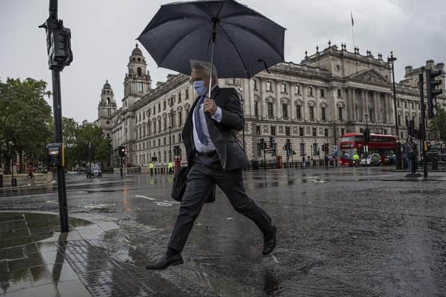
“Environment Agency teams are out on the ground and will support local authorities in responding to surface water flooding. We urge people not to drive through flood water - it is often deeper than it looks and just 30cm of flowing water is enough to float your car.”
In Yorkshire, the weather is set to be warm with more cloud than recent days on Saturday (June 17), but still bright or sunny spells will occur and most areas will remain dry with a maximum temperature of 26C. Light onshore winds will keep coastal areas cooler, with highest temperatures in the west. The evening will see scattered showers, with a few possible heavy and thundery showers that may develop, however, some areas will remain dry with clear spells. Low cloud is likely to arrive along the coast and the minimum temperature is set to be 10C.
On Sunday, June 18, there will be bright or sunny spells and an increasing chance of showers developing across the region. Some showers will be heavy and perhaps thundery. Cooler weather is expected along the coast with low cloud possibly lingering in places and a maximum temperature of 22C.
Advertisement
Hide AdAdvertisement
Hide AdHeavy rain is expected to clear on Sunday night and a chance of showers or thunderstorms each day is predicted, especially on Wednesday, June 21, with only isolated showers or thunderstorms on Monday, June 19 and Tuesday, June 20, though it will be generally warm or very warm.
When will thunderstorms hit Yorkshire?
The Met Office has predicted thunderstorms to begin on Saturday night and continue into next week, however, the yellow weather warning has been issued across the region today (Sunday, June 18), with some also being issued with the warning on Monday, June 19.
Below are the times these thunderstorms are expected to hit in each of the worst affected areas.
Leeds
Thunderstorms are expected to hit the city today at 6pm.
York
While times have not been specified, a yellow weather warning for thunderstorm has been issued in York for today and for rain on Monday.
Sheffield
Advertisement
Hide AdAdvertisement
Hide AdThunderstorms are also expected to hit Sheffield four times today at 4pm, 5pm, 6pm and 7pm.
Halifax
In Halifax, thunderstorms are predicted three times at 5pm, 6pm and 7pm today.
Bradford
Thunderstorms are expected three times today at 4pm, 6pm and 7pm in Bradford.
Doncaster
Thunderstorms in this newly appointed city are expected to hit three times today: at 4pm, 5pm and 6pm.
Huddersfield
Advertisement
Hide AdAdvertisement
Hide AdThere are thunderstorms expected this evening in Huddersfield at 6pm and 7pm.
Wakefield
Thunderstorms are set to hit at 6pm today in Wakefield.
Harrogate
No times have been confirmed when thunderstorms are predicted, but a yellow weather warning for thunderstorms has been issued for today and a yellow weather warning has been issued for rain on Monday in Harrogate.