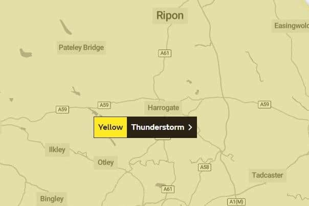
Met Office issues thunderstorm warning for Harrogate district on Monday
and live on Freeview channel 276
While some places stay dry, thunderstorms are likely to develop during Monday, bringing locally heavy rain and possible disruption.
As the hot weather subsides in the north, the change brings with it the risk of some intense thundery downpours and the chance of some surface water flooding.
Advertisement
Hide AdAdvertisement
Hide AdThe warning will begin from 6am on Monday morning and is set to last up until midnight.
As we head into the weekend, here is what the weather forecast is like across the Harrogate into next week…
S aturday (August 13)
Hot and sunny day with mostly light winds
Maximum temperature – 29°C
Pollen – High
UV – High
Sunday (August 14)
Cloudy but still very warm in sunny spells
Maximum temperature – 28°C
Pollen – High
UV – High
Monday (August 15)
Rather cloudy with heavy, thundery showers possible throughout the day
Maximum temperature – 26°C
Pollen – Medium
UV – Medium
Tuesday (August 16)
Rather cloudy with heavy, thundery showers possible throughout the day
Maximum temperature – 20°C
Pollen – High
UV – Medium
Wednesday (August 17)
Advertisement
Hide AdAdvertisement
Hide AdCloudy throughout the day with much cooler temperatures forecast
Maximum temperature – 19°C
UV – Medium
Thursday (August 18)
Cloudy changing to sunny intervals by late morning
Maximum temperature – 20°C
UV – Medium
For a full weather forecast and for all the latest weather warnings across the region, head to www.metoffice.gov.uk