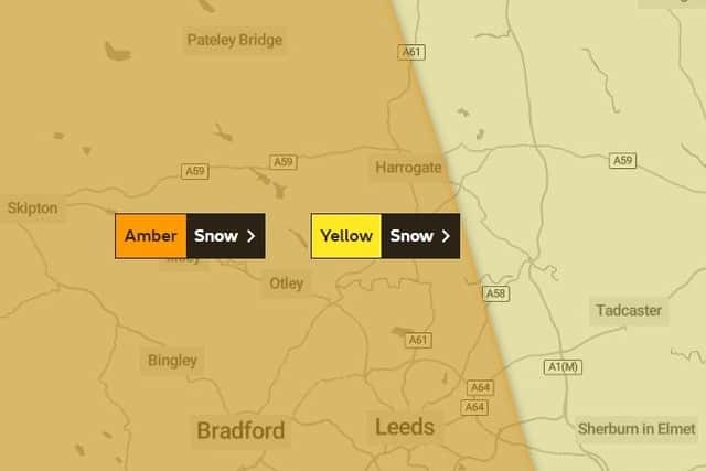
Met Office issues new amber weather warning for heavy snow – this is when it is expected to fall in Harrogate
and live on Freeview channel 276
The Met Office has increased the severity of its weather warning for heavy snow from yellow to amber.
It covers most of Yorkshire and is in place from 3pm on Thursday 9 March until 12pm on Friday 10 March.
Advertisement
Hide AdAdvertisement
Hide AdThe heavy snow is likely to cause significant disruption on Thursday afternoon and Friday morning, including travel delays on the roads which could cause some vehicles and passengers to become stranded.
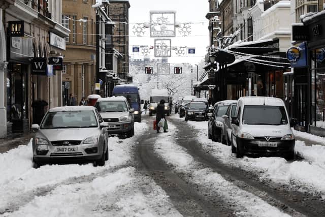

It is likely that there will also be some delays and cancellations to rail and air travel with travellers advised to check before they travel.
There is a good chance that some rural communities could become cut off, as well as power cuts and issues to other services such as mobile phone coverage.
Met Office Chief Meteorologist, Matthew Lehnert, said: “The boundary between milder and colder air will slowly move north through Wednesday and overnight, moving the chances of snow further north with it.
Advertisement
Hide AdAdvertisement
Hide Ad"Snow will have settled quite widely in central parts of the United Kingdom as we move into Thursday morning leaving tricky conditions for the morning travel period.
"It will be another very cold night, especially under clear skies in Scotland where temperatures could get down to -15°C again tonight.
“An amber warning for snow has been issued for the high ground running north in the centre of northern England as snow redevelops through the course of Thursday and persist until early Friday.
"Here we could see up to 40cm of snow accompanied by strong winds causing blizzard conditions.”
Advertisement
Hide AdAdvertisement
Hide AdHere is the weather forecast for the week ahead and when Harrogate can expect to see snow...
TODAY
Sleet changing to overcast by early evening
Temperature as high as 3°
Temperature as low as -1°
THURSDAY
Amber and yellow weather warning in place for heavy snow
Temperature as high as 2°
Temperature as low as 0°
8am – 50 per cent chance of snow
9am – 60 per cent chance of snow
10am – 60 per cent chance of snow
11am – 60 per cent chance of snow
12pm – 80 per cent chance of snow
1pm – 60 per cent chance of snow
2pm – 60 per cent chance of snow
3pm – 60 per cent chance of snow
4pm – 60 per cent chance of snow
5pm – 60 per cent chance of snow
6pm – 80 per cent chance of snow
7pm – 80 per cent chance of snow
8pm – 80 per cent chance of snow
9pm – 90 per cent chance of snow
10pm – 80 per cent chance of snow
11pm – 80 per cent chance of snow
FRIDAY
Amber and yellow weather warning in place for heavy snow
Temperature as high as 3°
Temperature as low as -5°
6am – 90 per cent chance of snow
9am – 70 per cent chance of snow
12pm – 40 per cent chance of snow
3pm – 10 per cent chance of snow
6pm – 5 per cent chance of snow
9pm – 5 per cent chance of snow
SATURDAY
Partly cloudy changing to sunny intervals by late morning
Temperature as high as 4°
Temperature as low as 1°
SUNDAY
Overcast changing to light rain by night time
Temperature as high as 10°
Temperature as low as 6°
To keep up-to-date with the latest weather forecast, visit https://www.metoffice.gov.uk/
Comment Guidelines
National World encourages reader discussion on our stories. User feedback, insights and back-and-forth exchanges add a rich layer of context to reporting. Please review our Community Guidelines before commenting.